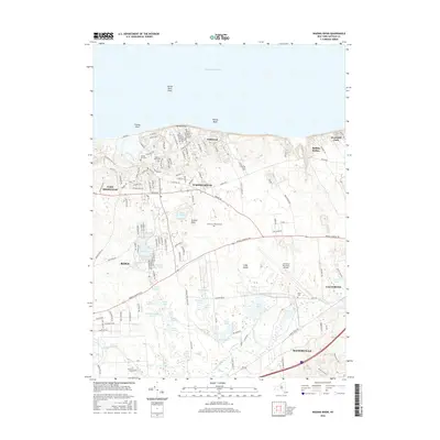
2016 Map of Wading River
USGS Topo · Published 2016About this map
Wading River and the surrounding north shore of Long Island are captured here during a period of modern residential development and preserved open space. The landscape is defined by its glacial heritage, featuring a dense network of kettle ponds such as Deep Pond, Lake Panamoka, and Peasys Pond clustered south of the Wading River settlement. Along the coast of the Long Island Sound, the Wildwood state park and the bluffs near Baiting Hollow maintain the shoreline's character, while the massive grounds of the Calverton National Cem occupy the central interior. To the south, the headwaters of the Peconic River weave through low-lying wetlands and bogs, contrasted by the rising elevations of the Manorville Hills. This survey documents the significant infrastructure of the Calverton Executive Airpark and the residential expansion in East Shoreham and Ridge.
Find a feature on this map
143 named features on this map. Tap any name to fly to it.
Don’t see what you’re looking for? This feature index may not catch every label — zoom into the map to look around manually.
Map Details
Editions of this 2016 Wading River Map
This is the sole edition of this map. No revisions or reprints were ever made.
Other maps of this area

1903 · Riverhead
USGS Topo · 1:62,500

1904 · Riverhead
USGS Topo · 1:62,500

1904 · Moriches
USGS Topo · 1:62,500

1943 · Riverhead
USGS Topo · 1:62,500

1947 · Bellport
USGS Topo · 1:24,000

1947 · Riverhead
USGS Topo · 1:24,000

1947 · Eastport
USGS Topo · 1:24,000
1947 · Middle Island
USGS Topo · 1:24,000

1947 · Hartford
USGS Topo · 1:250,000

1948 · Hartford
USGS Topo · 1:250,000