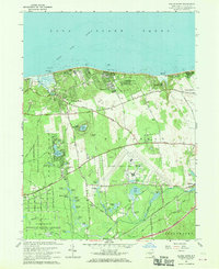
1967 Map of Wading River
USGS Topo · Published 1970About this map
Wading River and the northern shore of Suffolk County are defined here by a mix of mid-century scientific industry and recreational coastline. The sprawling U S Reservation of the Brookhaven National Laboratory dominates the western portion, while the Grumman Peconic River Airport and its associated industrial facilities occupy the central woods. This era captures the region before heavy suburbanization, showing a landscape still rich with named water bodies such as Lake Panamoka and Deep Pond. Along the Long Island Sound, Wildwood State Park and various camps like Camp Wauwepex and Camp Baiting Hollow illustrate the area's long-standing role as a summer destination. Inland, the presence of Cranberry Bogs near the Peconic River and a Scuttle Hole near Manorville point to the local agricultural and geological heritage of the island.
Find a feature on this map
82 named features on this map. Tap any name to fly to it.
Don’t see what you’re looking for? This feature index may not catch every label — zoom into the map to look around manually.
Map Details
Editions of this 1967 Wading River Map
This is the sole edition of this map. No revisions or reprints were ever made.
Other maps of this area

1903 · Riverhead
USGS Topo · 1:62,500

1904 · Riverhead
USGS Topo · 1:62,500

1904 · Moriches
USGS Topo · 1:62,500

1943 · Riverhead
USGS Topo · 1:62,500

1947 · Bellport
USGS Topo · 1:24,000

1947 · Riverhead
USGS Topo · 1:24,000

1947 · Eastport
USGS Topo · 1:24,000
1947 · Middle Island
USGS Topo · 1:24,000

1947 · Hartford
USGS Topo · 1:250,000

1948 · Hartford
USGS Topo · 1:250,000