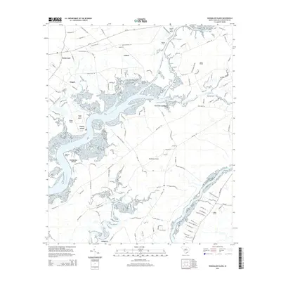
2014 Map of Wadmalaw Island
USGS Topo · Published 2014About this map
Wadmalaw Island and the neighboring sea island communities are defined by a complex network of tidal waterways, including the Wadmalaw River and Bohicket Creek. In this modern topographic survey, the landscape reveals a mixture of agricultural heritage and residential growth along the Intracoastal Waterway. The layout of large tracts like Dixie Plantation Rd and Stono Plantation Dr reflects the deep-rooted land use patterns of the South Carolina Lowcountry. Smaller settlements such as Meggett, Hollywood, and Yonges Island anchor the western portion of the map, while New Cut Landing and Goshen Point mark significant points along the interior reaches of the Stono River. For local historians and genealogists, the map provides precise locations for family landmarks and burial sites like Chaplin Cem and Parker Cem, situated amidst a coastal environment of bluffs and marshlands like Church Flats Bluff and Martins Point.
Find a feature on this map
127 named features on this map. Tap any name to fly to it.
Don’t see what you’re looking for? This feature index may not catch every label — zoom into the map to look around manually.
Map Details
Editions of this 2014 Wadmalaw Island Map
This is the sole edition of this map. No revisions or reprints were ever made.
Other maps of this area

1918 · Kiawah Island
USGS Topo · 1:21,120

1918 · Cottageville
USGS Topo · 1:62,500

1919 · Johns Island
USGS Topo · 1:21,120

1919 · Edisto Island
USGS Topo · 1:62,500

1919 · Wadmelaw Island
USGS Topo · 1:62,500

1919 · Legareville
USGS Topo · 1:21,120

1920 · Ravenels
USGS Topo · 1:62,500

1943 · Cottageville
USGS Topo · 1:62,500

1943 · Legareville
USGS Topo · 1:24,000

1943 · Edisto Island
USGS Topo · 1:62,500