
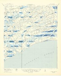
1919 Map of Wadmelaw Island
USGS Topo · Published 1919About this map
Wadmelaw Island and the neighboring sea islands of Johns Island, Kiawah Island, and Seabrook Island define this coastal landscape at the end of the First World War. The area is characterized by a complex network of tidal waterways, including the Stono River and Bohicket Creek, which served as the primary arteries for local commerce and travel before modern bridge connections were fully established. The settlement at Rockville sits at the tip of Wadmelaw, while the interior of the islands is dotted with rural institutions like Brickhouse School and St Johns Church, reflecting a deeply rooted agricultural and fishing society.
Find a feature on this map
73 named features on this map. Tap any name to fly to it.
Don’t see what you’re looking for? This feature index may not catch every label — zoom into the map to look around manually.
Map Details
Editions of this 1919 Wadmelaw Island Map
2 editions found
Other maps of this area

1918 · Kiawah Island
USGS Topo · 1:21,120

1918 · Cottageville
USGS Topo · 1:62,500

1919 · Johns Island
USGS Topo · 1:21,120

1919 · Edisto Island
USGS Topo · 1:62,500

1919 · Charleston
USGS Topo · 1:21,120

1919 · James Island
USGS Topo · 1:21,120

1919 · Legareville
USGS Topo · 1:21,120

1920 · St. Helena Sound
USGS Topo · 1:62,500

1920 · Ravenels
USGS Topo · 1:62,500

1943 · Cottageville
USGS Topo · 1:62,500