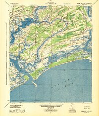
1944 Map of Wadmelaw Island
USGS Topo · Published 1944About this map
Wadmelaw Island and its surrounding sea islands appear in this mid-century survey as a complex network of coastal hamlets and maritime infrastructure. The Seaboard Air Line railroad terminates near Meggett, serving a landscape where river transport remained vital at locations like Yonges Island and Rockville. The interior of the islands is dotted with community centers such as the Jerusalem Soc, while a dense system of rural education is visible through several labeled buildings including Brickhouse Sch, Sandhill Sch, and Hopkins Sch. Along the Atlantic Ocean coastline, Kiawah Island and Seabrook Island show a largely undeveloped state prior to modern resort expansion, though the Kiawaco Club is noted near the Bohicket Creek outlet. The map also records several local houses of worship, such as Enterprise Ch and St Johns Ch, anchoring the various small settlements.
Find a feature on this map
54 named features on this map. Tap any name to fly to it.
Don’t see what you’re looking for? This feature index may not catch every label — zoom into the map to look around manually.
Map Details
Editions of this 1944 Wadmelaw Island Map
2 editions found

Other maps of this area

1918 · Kiawah Island
USGS Topo · 1:21,120

1918 · Cottageville
USGS Topo · 1:62,500

1919 · Johns Island
USGS Topo · 1:21,120

1919 · Edisto Island
USGS Topo · 1:62,500

1919 · Wadmelaw Island
USGS Topo · 1:62,500

1919 · Charleston
USGS Topo · 1:21,120

1919 · James Island
USGS Topo · 1:21,120

1919 · Legareville
USGS Topo · 1:21,120

1920 · St. Helena Sound
USGS Topo · 1:62,500

1920 · Ravenels
USGS Topo · 1:62,500