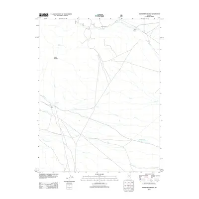
2012 Map of Wadsworth Ranch
USGS Topo · Published 2012About this map
Isolated ranchsteads and scattered water sources define this high-desert portion of Nye County in the early 21st century. The landscape is marked by the presence of Wadsworth Ranch, Uhalde Ranch, and Walch Ranch, which serve as the primary human settlements in an area dominated by dry washes and seasonal creeks. Life here is tethered to vital water points such as Modes Hole Spring, Battaman Spring, and the Garden Valley Reservoir Number 1. This map reveals a complex network of forest and ranch roads, including the National Forest Dev Rd and Pine Creek Rd, which navigate the terrain between Mystery Mountain and the deep cut of Cherry Canyon. The drainage patterns of Pine Cr, Sand Cr, and Cottonwood Cr provide the physical structure for the region's limited agricultural and pastoral activity.
Find a feature on this map
19 named features on this map. Tap any name to fly to it.
Don’t see what you’re looking for? This feature index may not catch every label — zoom into the map to look around manually.
Map Details
Editions of this 2012 Wadsworth Ranch Map
This is the sole edition of this map. No revisions or reprints were ever made.
Other maps of this area

1942 · Penoyer Valley
USGS Topo · 1:125,000

1954 · Caliente
USGS Topo · 1:250,000

1956 · Lund
USGS Topo · 1:250,000

1959 · Caliente
USGS Topo · 1:250,000

1960 · Lund
USGS Topo · 1:250,000

1985 · Adaven
USGS Topo · 1:24,000

1985 · Worthington Peak
USGS Topo · 1:24,000

1985 · McCutchen Spring
USGS Topo · 1:24,000
1985 · Badger Gulch
USGS Topo · 1:24,000

1985 · Murphy Gap NW
USGS Topo · 1:24,000