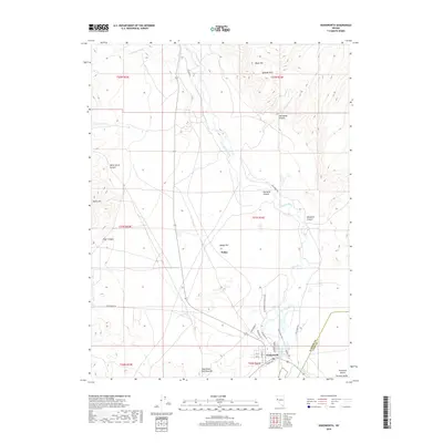
2018 Map of Wadsworth
USGS Topo · Published 2018About this map
Wadsworth sits at a geographic crossroads in Nevada, where the Truckee River bends southward near the edge of the Fortymile Desert. The settlement's street grid, including Jackson St and Herman Ave, reflects a layout influenced by its proximity to the rail corridor, evidenced by Railroad Dr. To the north, the landscape is defined by a series of prominent canyons such as Gardella Canyon and Hill Ranch Canyon, which cut through the high ground of the Diabase Hills and Black Mtn. This desert terrain highlights the importance of the river as a life-giving artery for the surrounding Dodge Flat and Fernley Valley. Modern infrastructure follows long-established routes, including the historic Lincoln Highway and Reservation Road, which serve as the primary conduits through this transition zone between the river valley and the arid stretches of the Pyramid Lake Paiute Reservation.
Find a feature on this map
38 named features on this map. Tap any name to fly to it.
Don’t see what you’re looking for? This feature index may not catch every label — zoom into the map to look around manually.
Map Details
Editions of this 2018 Wadsworth Map
This is the sole edition of this map. No revisions or reprints were ever made.
Other maps of this area

1890 · Wadsworth
USGS Topo · 1:125,000

1892 · Wadsworth
USGS Topo · 1:125,000

1894 · Wadsworth
USGS Topo · 1:125,000

1957 · Fireball Ridge
USGS Topo · 1:62,500

1957 · Two Tips
USGS Topo · 1:62,500

1957 · Wadsworth
USGS Topo · 1:62,500

1957 · Nixon
USGS Topo · 1:62,500

1957 · Reno
USGS Topo · 1:250,000

1959 · Reno
USGS Topo · 1:250,000

1960 · Reno
USGS Topo · 1:250,000