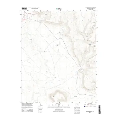
2013 Map of Waggoner Ranch
USGS Topo · Published 2013About this map
Waggoner Ranch and the Bell Ranch Waggoner Airport anchor this high-desert landscape in San Miguel County. The terrain is defined by an intricate network of drainages and mesas, most notably the prominent Huerfano Mesa to the south and a series of deep cuts to the east including Mule Canyon, Devils Canyon, and Ensinosa Canyon. Water management is the primary sign of human activity across these ranch lands, evidenced by a string of named water sources such as the Upper La Cinta Windmill, Hospital Windmill, and Turtle Windmill. These features follow the course of La Cinta Cr, illustrating the essential relationship between reliable water and livestock operations in this arid region. The map also traces the winding path of NM-433 as it navigates the breaks and canyons of the northeastern high plains.
Find a feature on this map
23 named features on this map. Tap any name to fly to it.
Don’t see what you’re looking for? This feature index may not catch every label — zoom into the map to look around manually.
Map Details
Editions of this 2013 Waggoner Ranch Map
This is the sole edition of this map. No revisions or reprints were ever made.
Other maps of this area

1954 · Santa Fe
USGS Topo · 1:250,000

1954 · Tucumcari
USGS Topo · 1:250,000

1958 · Santa Fe
USGS Topo · 1:250,000

1958 · Tucumcari
USGS Topo · 1:250,000
1969 · Campana
USGS Topo · 1:24,000

1969 · Chinaberry Canyon
USGS Topo · 1:24,000
1972 · Bell Ranch
USGS Topo · 1:24,000

1972 · Montoya Point
USGS Topo · 1:24,000

1972 · Waggoner Ranch
USGS Topo · 1:24,000
1972 · Minese Mesa
USGS Topo · 1:24,000