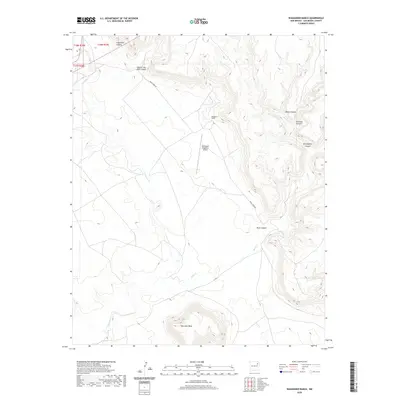
2020 Map of Waggoner Ranch
USGS Topo · Published 2020About this map
Waggoner Ranch and its associated Bell-Ranch Waggoner Airport center this ranching landscape in San Miguel County. The terrain is defined by a complex network of canyons and mesas, with Huerfano Mesa rising prominently in the south and Hole-in-the-Wall Canyon cutting through the northern reaches. This modern survey illustrates the enduring nature of the large-scale cattle operations in this part of New Mexico, where infrastructure like Mule Creek Dr follows the natural contours of the drainage systems. Water courses such as La Cinta Cr, Mule Cr, and Devils Cr navigate between named formations including Carpenter Canyon and Seventyfour Canyon, revealing a land where topographical features dictate the placement of roads and remote airfields.
Find a feature on this map
16 named features on this map. Tap any name to fly to it.
Don’t see what you’re looking for? This feature index may not catch every label — zoom into the map to look around manually.
Map Details
Editions of this 2020 Waggoner Ranch Map
This is the sole edition of this map. No revisions or reprints were ever made.
Other maps of this area

1954 · Santa Fe
USGS Topo · 1:250,000

1954 · Tucumcari
USGS Topo · 1:250,000

1958 · Santa Fe
USGS Topo · 1:250,000

1958 · Tucumcari
USGS Topo · 1:250,000
1969 · Campana
USGS Topo · 1:24,000

1969 · Chinaberry Canyon
USGS Topo · 1:24,000
1972 · Bell Ranch
USGS Topo · 1:24,000

1972 · Montoya Point
USGS Topo · 1:24,000

1972 · Waggoner Ranch
USGS Topo · 1:24,000
1972 · Minese Mesa
USGS Topo · 1:24,000