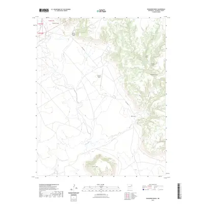
2023 Map of Waggoner Ranch
USGS Topo · Published 2023About this map
Bell Ranch Waggoner Airport serves as a modern waypoint in this expansive cattle country of San Miguel County, where the topography is defined by a complex network of drainages and high ground. The landscape is deeply incised by Carpenter Canyon and Hole-in-the-Wall Canyon to the north, while the southern reaches are dominated by the prominent Huerfano Mesa. Water flows, primarily seasonal, dictate the movement through this terrain, with La Cinta Creek and Mule Creek carving paths through the alluvial flats. The presence of Mule Creek Dr provides the primary overland access through a region characterized by dramatic elevation shifts, ranging from the steep walls of Devils Canyon to the broader expanse of Seventyfour Canyon. This survey captures the intersection of ranching infrastructure and the natural erosive features of the New Mexico high plains.
Find a feature on this map
15 named features on this map. Tap any name to fly to it.
Don’t see what you’re looking for? This feature index may not catch every label — zoom into the map to look around manually.
Map Details
Editions of this 2023 Waggoner Ranch Map
This is the sole edition of this map. No revisions or reprints were ever made.
Other maps of this area

1954 · Santa Fe
USGS Topo · 1:250,000

1954 · Tucumcari
USGS Topo · 1:250,000

1958 · Santa Fe
USGS Topo · 1:250,000

1958 · Tucumcari
USGS Topo · 1:250,000
1969 · Campana
USGS Topo · 1:24,000

1969 · Chinaberry Canyon
USGS Topo · 1:24,000
1972 · Bell Ranch
USGS Topo · 1:24,000

1972 · Montoya Point
USGS Topo · 1:24,000

1972 · Waggoner Ranch
USGS Topo · 1:24,000
1972 · Minese Mesa
USGS Topo · 1:24,000