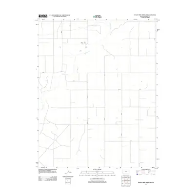
2012 Map of Wagon Bed Spring SW
USGS Topo · Published 2012About this map
The Cimarron River winds through the southwestern corner of Stevens County, carving a subtle path through a landscape otherwise defined by the rigid geometry of the Public Land Survey System. This 2012 survey documents the agricultural and energy-producing heartland of the High Plains, where the grid of county roads serves as the primary infrastructure. The intersection of Road 7 and Road W anchors the central portion of the quadrangle, illustrating the systematic division of land that has characterized the Kansas prairie since the late 19th century. While the river provides the only significant natural break in the terrain, the presence of numerous numbered thoroughfares such as 8mi Rd and Z Blvd indicates a well-developed network of rural access. This map is essential for understanding the modern spatial organization of the region, showing how the local road system accommodates the vast scale of contemporary farming and land management.
Find a feature on this map
13 named features on this map. Tap any name to fly to it.
Don’t see what you’re looking for? This feature index may not catch every label — zoom into the map to look around manually.
Map Details
Editions of this 2012 Wagon Bed Spring SW Map
This is the sole edition of this map. No revisions or reprints were ever made.
Other maps of this area

1955 · Dodge City
USGS Topo · 1:250,000

1958 · Dodge City
USGS Topo · 1:250,000

1959 · Dodge City
USGS Topo · 1:250,000

1973 · Rolla NE
USGS Topo · 1:24,000

1974 · Hugoton
USGS Topo · 1:24,000

1974 · Feterita
USGS Topo · 1:24,000
1974 · Wagon Bed Spring NW
USGS Topo · 1:24,000

1974 · Shore Airport SE
USGS Topo · 1:24,000
1974 · Wagon Bed Spring SW
USGS Topo · 1:24,000
1974 · Wagon Bed Spring
USGS Topo · 1:24,000