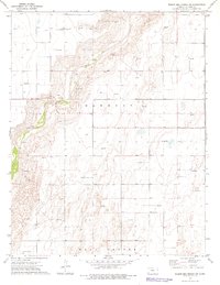
1974 Map of Wagon Bed Spring SW
USGS Topo · Published 1976About this map
The Old Santa Fe Trail (Approximate Location) cuts across the northern edge of this Stevens County landscape, marking the historic path of commerce through the High Plains. This 1970s survey documents a region defined by the winding course of the Cimarron River and the systematic development of the Hugoton gas field. The terrain is divided into the administrative townships of Harmony and West Center, where the economy of the era is evidenced by the proliferation of Gas Wells and localized industrial activity at several Sandpits. The map illustrates the 20th-century layering of energy extraction and modern land division over the foundational tracks of the mid-19th-century wagon trade.
Find a feature on this map
7 named features on this map. Tap any name to fly to it.
Don’t see what you’re looking for? This feature index may not catch every label — zoom into the map to look around manually.
Map Details
Editions of this 1974 Wagon Bed Spring SW Map
This is the sole edition of this map. No revisions or reprints were ever made.
Other maps of this area

1955 · Dodge City
USGS Topo · 1:250,000

1958 · Dodge City
USGS Topo · 1:250,000

1959 · Dodge City
USGS Topo · 1:250,000

1973 · Rolla NE
USGS Topo · 1:24,000

1974 · Hugoton
USGS Topo · 1:24,000

1974 · Feterita
USGS Topo · 1:24,000
1974 · Wagon Bed Spring NW
USGS Topo · 1:24,000

1974 · Shore Airport SE
USGS Topo · 1:24,000
1974 · Wagon Bed Spring
USGS Topo · 1:24,000
1974 · Wagon Bed Spring SE
USGS Topo · 1:24,000