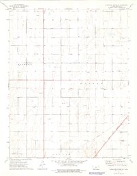
1974 Map of Wagon Bed Spring SE
USGS Topo · Published 1976About this map
Harmony and Moscow townships define the landscape of Stevens County in the mid-1970s, an area where the agricultural grid is deeply intertwined with the energy industry. The terrain is marked by a dense concentration of Gas Well and Oil Well symbols, reflecting the significance of the Hugoton Gas Area during this era. Industrial infrastructure is prominent throughout the map, including a major Pipeline corridor cutting diagonally across the southeastern portion of the quadrangle. Transport and logistics are anchored by the Atchison Topeka and Santa Fe railroad, which runs parallel to the pipeline, serving as a vital link for the regional economy. Transitioning southward into West Center and Center, the map provides a clear view of the rural section lines and fence boundaries that organized Kansas prairie life decades ago.
Find a feature on this map
10 named features on this map. Tap any name to fly to it.
Don’t see what you’re looking for? This feature index may not catch every label — zoom into the map to look around manually.
Map Details
Editions of this 1974 Wagon Bed Spring SE Map
This is the sole edition of this map. No revisions or reprints were ever made.
Other maps of this area

1944 · Moscow
USGS Topo · 1:62,500

1945 · Moscow
USGS Topo · 1:62,500

1955 · Dodge City
USGS Topo · 1:250,000

1958 · Dodge City
USGS Topo · 1:250,000

1959 · Dodge City
USGS Topo · 1:250,000

1974 · Hugoton
USGS Topo · 1:24,000

1974 · Feterita
USGS Topo · 1:24,000
1974 · Wagon Bed Spring NW
USGS Topo · 1:24,000
1974 · Wagon Bed Spring SW
USGS Topo · 1:24,000
1974 · Wagon Bed Spring
USGS Topo · 1:24,000