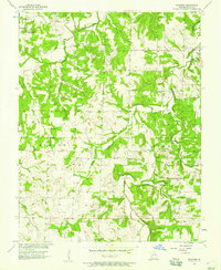
1956 Map of Wagoner
USGS Topo · Published 1957About this map
Wagoner sits at the heart of this mid-century portrait of Cedar County, Missouri, where the landscape is defined by the winding paths of Horse Creek and Cedar Creek. The map records a rural community in transition, noting both active and former landmarks such as the Sand Ridge Sch (Abandoned) and the Sand Ridge Cem (Abandoned) in the northwest corner. The social fabric of the era is evident in the placement of the Amity Community Hall and Independence Community Hall, alongside local spiritual centers like Hopewell Ch and Independence Ch. The terrain transitions from the bottomlands of Stinking Creek to the prominent rise of Boston Bluff, while several bridges, including Vasser Ford Bridge and Hopewell Bridge, mark the essential crossings for local commerce and travel between Benton and Linn townships.
Find a feature on this map
28 named features on this map. Tap any name to fly to it.
Don’t see what you’re looking for? This feature index may not catch every label — zoom into the map to look around manually.
Map Details
Editions of this 1956 Wagoner Map
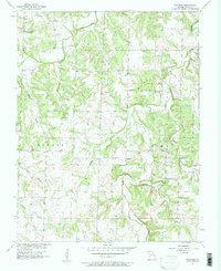
2 editions found
Other maps of this area

1886 · Nevada
USGS Topo · 1:125,000

1886 · Stockton
USGS Topo · 1:125,000

1894 · Nevada
USGS Topo · 1:125,000

1939 · Caplinger Mills
USGS Topo · 1:24,000

1939 · Filley
USGS Topo · 1:24,000

1939 · Eldorado Springs South
USGS Topo · 1:24,000

1940 · Filley
USGS Topo · 1:24,000

1941 · Caplinger Mills
USGS Topo · 1:24,000
1942 · Eldorado Springs South
USGS Topo · 1:24,000

1947 · Joplin
USGS Topo · 1:250,000