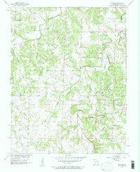
1956 Map of Wagoner
USGS Topo · Published 1957About this map
Wagoner and the surrounding rural landscape of Cedar County appear in this mid-century survey, revealing a network of small family cemeteries and country institutions. The land is divided by the boundary between Benton and Linn townships, with Cedar Creek winding through the center of the sheet. Notable local landmarks include the Sand Ridge Sch, marked as abandoned by the time of this field check, and several active gathering places such as Amity Community Hall and Independence Community Hall. The topography is defined by prominent rises like Hyder Hill and riverine features including Boston Bluff. Transportation in the area relied on crossings like the Vasser Ford Bridge and Hopewell Bridge, connecting isolated farmsteads to the spiritual and social hubs of Hopewell Ch and Independence Ch. These features suggest a community structure centered on small-scale agriculture and established local parishes.
Find a feature on this map
27 named features on this map. Tap any name to fly to it.
Don’t see what you’re looking for? This feature index may not catch every label — zoom into the map to look around manually.
Map Details
Editions of this 1956 Wagoner Map
2 editions found
Other maps of this area

1886 · Nevada
USGS Topo · 1:125,000

1886 · Stockton
USGS Topo · 1:125,000

1894 · Nevada
USGS Topo · 1:125,000

1939 · Caplinger Mills
USGS Topo · 1:24,000

1939 · Filley
USGS Topo · 1:24,000

1939 · Eldorado Springs South
USGS Topo · 1:24,000

1940 · Filley
USGS Topo · 1:24,000

1941 · Caplinger Mills
USGS Topo · 1:24,000
1942 · Eldorado Springs South
USGS Topo · 1:24,000

1947 · Joplin
USGS Topo · 1:250,000