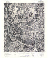
1972 Map of Wagoner NW
USGS Topo · Published 1974About this map
The Verdigris River defines the lower-left landscape of this 1972 orthophotomosaic, its sinuous loops and oxbows carved into the floodplain west of Wagoner. This aerial perspective, captured in late December, reveals a clear grid of agricultural fields and pastures that dominate the terrain north and west of the city limits. The residential and commercial density of Wagoner is concentrated in the eastern portion of the map, showing the physical layout of the town as it appeared in the early 1970s. Narrower waterways like Billy Creek drain the surrounding acreage, while a prominent highway corridor cuts across the river valley, providing a sharp contrast to the natural meandering of the water. For local historians, this photographic record is invaluable for tracing the exact boundaries of mid-century development and the transition from riverine woodland to cleared farmland.
Find a feature on this map
4 named features on this map. Tap any name to fly to it.
Don’t see what you’re looking for? This feature index may not catch every label — zoom into the map to look around manually.
Map Details
Editions of this 1972 Wagoner NW Map
This is the sole edition of this map. No revisions or reprints were ever made.
Other maps of this area

1896 · Okmulgee
USGS Topo · 1:125,000

1896 · Pryor
USGS Topo · 1:125,000

1900 · Okmulgee
USGS Topo · 1:125,000

1901 · Muscogee
USGS Topo · 1:125,000

1901 · Claremore
USGS Topo · 1:125,000

1901 · Pryor
USGS Topo · 1:125,000

1905 · Muscogee
USGS Topo · 1:125,000

1914 · Claremore
USGS Topo · 1:125,000

1916 · Claremore
USGS Topo · 1:125,000

1946 · Fort Smith
USGS Topo · 1:250,000