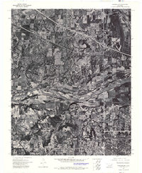
1972 Map of Wagoner SW
USGS Topo · Published 1974About this map
The confluence of two major waterways dominates this orthophotomosaic, where the Verdigris River meets the sweeping curves of the Arkansas River. Based on aerial photography from December 1972, this view reveals the intensive agricultural grid and river-bottom lands of the region just north of the city. The northern edge of Muskogee is visible in the lower right, contrasting with the more dispersed rural layout of Tullahassee to the north. These images capture the landscape at a specific moment in the early 1970s, documenting the field patterns, riparian vegetation, and the winding path of Cane Creek as it feeds the larger river system. Unlike traditional line-drawn maps, this photo-based study provides an unfiltered look at the actual land use and drainage patterns of the era.
Find a feature on this map
5 named features on this map. Tap any name to fly to it.
Don’t see what you’re looking for? This feature index may not catch every label — zoom into the map to look around manually.
Map Details
Editions of this 1972 Wagoner SW Map
This is the sole edition of this map. No revisions or reprints were ever made.
Other maps of this area

1896 · Okmulgee
USGS Topo · 1:125,000

1900 · Okmulgee
USGS Topo · 1:125,000

1901 · Muscogee
USGS Topo · 1:125,000

1905 · Muscogee
USGS Topo · 1:125,000

1946 · Fort Smith
USGS Topo · 1:250,000

1948 · Keefeton
USGS Topo · 1:62,500

1948 · Wagoner
USGS Topo · 1:62,500

1950 · Keefeton
USGS Topo · 1:62,500

1950 · Wagoner
USGS Topo · 1:62,500
1963 · Red Bird
USGS Topo · 1:24,000