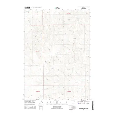
2015 Map of Wagonhound Creek NE
USGS Topo · Published 2015About this map
Cheyenne River winds through the northwestern corner of this landscape, carving through a high-plains terrain defined by a complex network of seasonal drainages. Water management in this arid environment is evident at Fred Number 1 Reservoir, a man-made feature that anchors the northern sections. The map reveals a system of named draws, including Fred Draw, Windmill Draw, and Piney Draw, which channel runoff toward more significant tributaries. These geological depressions reflect the practical naming conventions of local ranching and land use. Throughout the quadrangle, Owl Cr and Snyder Cr trace the low points of the topography, providing a detailed view of the natural hydrology that has shaped the boundaries and routes of this part of Wyoming. This 2015 survey illustrates how the drainage patterns and small reservoirs remain the primary geographic landmarks in this rural expanse.
Find a feature on this map
13 named features on this map. Tap any name to fly to it.
Don’t see what you’re looking for? This feature index may not catch every label — zoom into the map to look around manually.
Map Details
Editions of this 2015 Wagonhound Creek NE Map
This is the sole edition of this map. No revisions or reprints were ever made.
Other maps of this area

1955 · Newcastle
USGS Topo · 1:250,000

1958 · Newcastle
USGS Topo · 1:250,000

1979 · Newcastle
USGS Topo · 1:100,000

1981 · Calf Draw
USGS Topo · 1:24,000
1981 · Wagonhound Creek
USGS Topo · 1:24,000

1981 · Pinnacle Rocks
USGS Topo · 1:24,000

1981 · Dixon Ranch
USGS Topo · 1:24,000

1981 · Garland Draw
USGS Topo · 1:24,000

1981 · Wagonhound Creek NE
USGS Topo · 1:24,000

1981 · Lance Creek
USGS Topo · 1:100,000