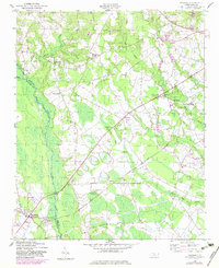
1949 Map of Wagram
USGS Topo · Published 1983About this map
The Lumber River forms a dominant natural boundary between Hoke and Scotland Counties, anchoring a landscape defined by its wetlands and small agricultural communities. This 1949 survey illustrates the established rural infrastructure of the North Carolina Sandhills, where the Aberdeen and Rockfish RR and Laurinburg and Southern RR provided vital transport links for the region's economy. The map reveals a dense network of local landmarks, including family-named cemeteries like Purcell Cem and McMillan Cem, alongside numerous educational sites such as Buffalo Springs Sch and Macedonia Sch. Settlements like Wagram and Bowmore serve as focal points for the surrounding farmsteads, while the winding courses of Buffalo Swamp and Raft Swamp indicate the low-lying, water-rich terrain that influenced the placement of roads and homesteads during the mid-century era.
Find a feature on this map
31 named features on this map. Tap any name to fly to it.
Don’t see what you’re looking for? This feature index may not catch every label — zoom into the map to look around manually.
Map Details
Editions of this 1949 Wagram Map
2 editions found
Other maps of this area

1948 · Southern Pines
USGS Topo · 1:62,500

1948 · Clifdale
USGS Topo · 1:62,500

1948 · Pinebluff
USGS Topo · 1:24,000

1948 · Nicholson Creek
USGS Topo · 1:24,000

1948 · Mc Cain
USGS Topo · 1:24,000

1949 · Wagram
USGS Topo · 1:24,000

1949 · Laurinburg
USGS Topo · 1:24,000

1949 · Silver Hill
USGS Topo · 1:24,000

1949 · Wakulla
USGS Topo · 1:24,000

1949 · Laurinburg
USGS Topo · 1:62,500