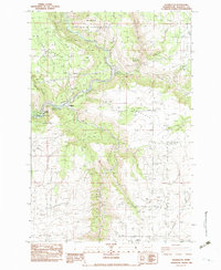
1983 Map of Wahkiacus
USGS Topo · Published 1983About this map
Wahkiacus occupies a strategic bend in the Klickitat River where its waters meet the Little Klickitat River. This early 1980s survey reveals a landscape of high plateau prairies and deeply incised canyons. To the south, High Prairie and Crofton Prairie overlook the dramatic descent into Swale Canyon, while the northern reaches include the Klickitat State Wildlife Recreation Area.
Find a feature on this map
22 named features on this map. Tap any name to fly to it.
Don’t see what you’re looking for? This feature index may not catch every label — zoom into the map to look around manually.
Map Details
Editions of this 1983 Wahkiacus Map
This is the sole edition of this map. No revisions or reprints were ever made.
Other maps of this area

1934 · The Dalles
USGS Topo · 1:125,000

1953 · The Dalles
USGS Topo · 1:250,000

1956 · The Dalles
USGS Topo · 1:250,000

1957 · The Dalles
USGS Topo · 1:250,000

1957 · Klickitat
USGS Topo · 1:62,500

1957 · Goldendale
USGS Topo · 1:62,500

1957 · The Dalles
USGS Topo · 1:62,500

1957 · Wishram
USGS Topo · 1:62,500

1974 · Stacker Butte
USGS Topo · 1:24,000

1974 · The Dalles North
USGS Topo · 1:24,000