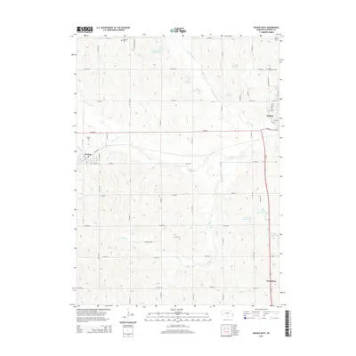
2014 Map of Wahoo West
USGS Topo · Published 2014About this map
The village of Weston and the western reaches of the Saunders county seat, Wahoo, anchor this agricultural landscape in eastern Nebraska. The map reveals a community defined by its cultural heritage, evidenced by a concentration of rural cemeteries including the Czech Cem, Saint Wenceslaus Cem, and Lutheran Cem. These sites, along with the Weston Cem, provide significant markers for those tracing local family roots and early settlement patterns. The terrain is shaped by the winding paths of Cottonwood Cr and Wahoo Cr, punctuated by a series of irrigation and flood control structures like Kavan Reservoir 1 and Thorston Reservoir B-2. To the south, the small settlement of Swedeburg lies near the headwaters of Miller Br. The topography is relatively gentle, rising to local high points such as Skunk Hill in the northeast corner. This map provides a detailed view of the section-line road network and the rural infrastructure supporting the region's farming economy during the early 21st century.
Find a feature on this map
55 named features on this map. Tap any name to fly to it.
Don’t see what you’re looking for? This feature index may not catch every label — zoom into the map to look around manually.
Map Details
Editions of this 2014 Wahoo West Map
This is the sole edition of this map. No revisions or reprints were ever made.
Other maps of this area

1899 · Wahoo
USGS Topo · 1:125,000

1955 · Fremont
USGS Topo · 1:250,000

1957 · Fremont
USGS Topo · 1:250,000

1958 · Fremont
USGS Topo · 1:250,000
1969 · Malmo
USGS Topo · 1:24,000
1969 · Touhy
USGS Topo · 1:24,000
1969 · Valparaiso
USGS Topo · 1:24,000
1969 · Colon
USGS Topo · 1:24,000
1969 · Prague
USGS Topo · 1:24,000
1969 · Ceresco
USGS Topo · 1:24,000