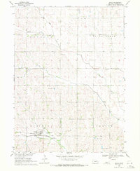
1969 Map of Malmo
USGS Topo · Published 1969About this map
The village of Malmo anchors this agrarian landscape in Saunders County, situated along the Burlington Northern railroad corridor. The area is defined by its rural community structure, where numerous numbered schoolhouses—such as School No 34, School No 61, School No 26, and School No 75—reflect the dense network of local school districts common in the late 1960s. The terrain is marked by several significant drainages, including Cottonwood Creek, Sand Creek, Duck Creek, and Spring Creek, which navigate the rises of the prairie toward the southeast. Genealogists will find notable burial sites across the township boundaries of Mariposa and Douglas, including Holy Rosary Cem, St Johns Cem, and Bethesda Cem. In the far southeast corner, the elevation rises toward the landmark known as Skunk Hill, overlooking the surrounding watershed and rail lines.
Find a feature on this map
18 named features on this map. Tap any name to fly to it.
Don’t see what you’re looking for? This feature index may not catch every label — zoom into the map to look around manually.
Map Details
Editions of this 1969 Malmo Map
This is the sole edition of this map. No revisions or reprints were ever made.
Other maps of this area

1899 · Wahoo
USGS Topo · 1:125,000

1955 · Fremont
USGS Topo · 1:250,000

1957 · Fremont
USGS Topo · 1:250,000

1958 · Fremont
USGS Topo · 1:250,000
1968 · Malmo NW
USGS Topo · 1:24,000
1968 · Fremont West
USGS Topo · 1:24,000
1968 · North Bend
USGS Topo · 1:24,000
1969 · Touhy
USGS Topo · 1:24,000
1969 · Colon
USGS Topo · 1:24,000
1969 · Prague
USGS Topo · 1:24,000