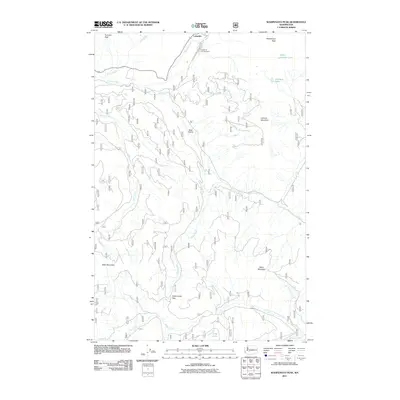
2011 Map of Wahpenayo Peak
USGS Topo · Published 2011About this map
Longmire serves as a primary point of entry in the northern section of this survey, situated where the Nisqually River meets Kautz Creek. This area within Mount Rainier National Park includes the Longmire Campground and follows the winding path of Skate Creek Rd S as it moves south toward the Gifford Pinchot National Forest boundary. The landscape is defined by high alpine features including Wahpenayo Peak, Lookout Mountain, and Tumtum Peak.
Find a feature on this map
22 named features on this map. Tap any name to fly to it.
Don’t see what you’re looking for? This feature index may not catch every label — zoom into the map to look around manually.
Map Details
Editions of this 2011 Wahpenayo Peak Map
This is the sole edition of this map. No revisions or reprints were ever made.
Other maps of this area

1924 · Mt Rainier
USGS Topo · 1:96,000

1928 · Mt Rainier
USGS Topo · 1:125,000

1950 · Yakima
USGS Topo · 1:250,000

1958 · Yakima
USGS Topo · 1:250,000

1961 · Yakima
USGS Topo · 1:250,000

1962 · Randle
USGS Topo · 1:62,500

1962 · Packwood
USGS Topo · 1:62,500
1971 · Mt Rainier West
USGS Topo · 1:24,000
1971 · Mount Wow
USGS Topo · 1:24,000
1971 · Mt Rainier East
USGS Topo · 1:24,000