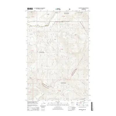
2014 Map of Wahpenayo Peak
USGS Topo · Published 2014About this map
Longmire serves as a focal point in this 2014 survey of the southern Cascades, situated where the Nisqually River flows beneath the dramatic Rampart Ridge. The landscape is dominated by the steep elevations of the Tatoosh Range, anchored by the high point of Wahpenayo Peak and Lookout Mtn. This high-altitude terrain is characterized by a complex drainage network, including Kautz Cr and Skate Cr, which carve through the heavily forested regions of Mount Rainier National Park and the adjacent Snoqualmie National Forest. To the south, Silver Creek Pass marks a significant transition point near Allen Mtn. The presence of Bear Prairie provides a distinct break in the alpine topography, while high lakes like Johnson Lake and Lake Fizrenken dot the ridges, reflecting the glacial history of the Pierce and Lewis County borderlands.
Find a feature on this map
43 named features on this map. Tap any name to fly to it.
Don’t see what you’re looking for? This feature index may not catch every label — zoom into the map to look around manually.
Map Details
Editions of this 2014 Wahpenayo Peak Map
This is the sole edition of this map. No revisions or reprints were ever made.
Other maps of this area

1924 · Mt Rainier
USGS Topo · 1:96,000

1928 · Mt Rainier
USGS Topo · 1:125,000

1950 · Yakima
USGS Topo · 1:250,000

1958 · Yakima
USGS Topo · 1:250,000

1961 · Yakima
USGS Topo · 1:250,000

1962 · Randle
USGS Topo · 1:62,500

1962 · Packwood
USGS Topo · 1:62,500
1971 · Mt Rainier West
USGS Topo · 1:24,000
1971 · Mount Wow
USGS Topo · 1:24,000
1971 · Mt Rainier East
USGS Topo · 1:24,000