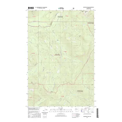
2017 Map of Wahpenayo Peak
USGS Topo · Published 2017About this map
Wahpenayo Peak and the Tatoosh Range dominate the high-elevation landscape where the Pierce Co and Lewis Co lines meet. This territory is split among three major federal management areas: Mount Rainier National Park in the north, Snoqualmie National Forest in the center, and Gifford Pinchot National Forest to the south and east. The drainage of the Nisqually River and the winding course of Skate Creek Rd S provide primary access through the mountain passes.
Find a feature on this map
51 named features on this map. Tap any name to fly to it.
Don’t see what you’re looking for? This feature index may not catch every label — zoom into the map to look around manually.
Map Details
Editions of this 2017 Wahpenayo Peak Map
This is the sole edition of this map. No revisions or reprints were ever made.
Other maps of this area

1924 · Mt Rainier
USGS Topo · 1:96,000

1928 · Mt Rainier
USGS Topo · 1:125,000

1950 · Yakima
USGS Topo · 1:250,000

1958 · Yakima
USGS Topo · 1:250,000

1961 · Yakima
USGS Topo · 1:250,000

1962 · Randle
USGS Topo · 1:62,500

1962 · Packwood
USGS Topo · 1:62,500
1971 · Mt Rainier West
USGS Topo · 1:24,000
1971 · Mount Wow
USGS Topo · 1:24,000
1971 · Mt Rainier East
USGS Topo · 1:24,000