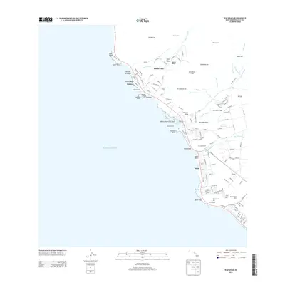
2013 Map of Waianae
USGS Topo · Published 2013About this map
Kāne'ākī Heiau stands as a significant cultural landmark in the upper reaches of the Mākaha Valley, highlighting the deep indigenous heritage preserved on this West O'ahu coastline. The transition from the steep inland peaks of Pu'ukawiwi and the Kamaileunu Ridge to the developed shorelines of Mākaha and Mā'ili illustrates the region's modern residential growth. Along the coast, distinctive geological features like the basaltic Mauna Lahilahi and Kepuhi Point frame the beaches, while the Waianae Kai Military Reservation Beach indicates the federal presence near Pōka'ī Bay. The interior landscape is marked by essential water infrastructure and ancient sites, including the Lualualei Reservoir and Kamailie Heiau, which sit between residential subdivisions and the rugged heights of the Pāhe'ehe'e Ridge.
Find a feature on this map
139 named features on this map. Tap any name to fly to it.
Don’t see what you’re looking for? This feature index may not catch every label — zoom into the map to look around manually.
Map Details
Editions of this 2013 Waianae Map
This is the sole edition of this map. No revisions or reprints were ever made.
Other maps of this area

1953 · Haleiwa
USGS Topo · 1:24,000

1953 · Schofield Barracks
USGS Topo · 1:24,000

1953 · Ewa
USGS Topo · 1:24,000

1954 · Oahu
USGS Topo · 1:250,000

1954 · Waianae
USGS Topo · 1:24,000

1954 · Kaena
USGS Topo · 1:24,000

1960 · Haleiwa
USGS Topo · 1:24,000

1960 · Schofield Barracks
USGS Topo · 1:24,000

1961 · Oahu
USGS Topo · 1:250,000
1962 · Ewa
USGS Topo · 1:24,000