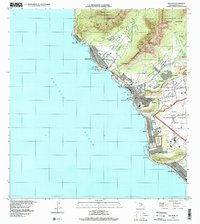
1998 Map of Waianae
USGS Topo · Published 2000About this map
Farrington Highway serves as the primary artery along this Leeward Coast landscape, connecting a string of coastal settlements between the Pacific Ocean and the steep ridges of the Makua Keauu Forest Reserve and Wai'anae Kai Forest Reserve. The map reveals a land use pattern defined by the transition from beachfront recreation at Mākaha Beach Park and Mā'ili Beach Park to the managed landscapes of the Wai'anae Homesteads and Lualualei Homesteads. A significant footprint is occupied by the Naval Transmitting Facility, situated on the flat coastal plain below Pu'u'ohulu Kai. Local community life is anchored by institutions such as Wai'anae High Sch and the Maunalahilahi Botanical Garden, while the presence of several quarries suggests the importance of industrial resource extraction in the valley interiors during this era.
Find a feature on this map
57 named features on this map. Tap any name to fly to it.
Don’t see what you’re looking for? This feature index may not catch every label — zoom into the map to look around manually.
Map Details
Editions of this 1998 Waianae Map
This is the sole edition of this map. No revisions or reprints were ever made.
Other maps of this area

1953 · Haleiwa
USGS Topo · 1:24,000

1953 · Schofield Barracks
USGS Topo · 1:24,000

1953 · Ewa
USGS Topo · 1:24,000

1954 · Oahu
USGS Topo · 1:250,000

1954 · Waianae
USGS Topo · 1:24,000

1954 · Kaena
USGS Topo · 1:24,000

1960 · Haleiwa
USGS Topo · 1:24,000

1960 · Schofield Barracks
USGS Topo · 1:24,000

1961 · Oahu
USGS Topo · 1:250,000
1962 · Ewa
USGS Topo · 1:24,000