1997 Map of Wailuku
USGS Topo · Published 1999About this map
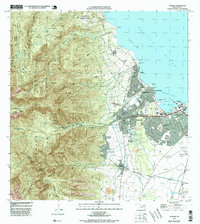
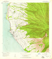
Wailuku stands as the central hub of Maui in this late-1990s survey, where the deep drainage of the Iao Valley meets the developed coastal plains of Kahului. The map captures a landscape defined by the transition from the high ridges of the West Maui Forest Reserve—including peaks like Lanilili and The Needle—to the industrial and residential corridors of Waikapu and Puunene. Agricultural history is visible through the Wailuku Mill and various irrigation features like the Waihee Flume, while the cultural landscape is anchored by the Haleki Pihana Heiau State Monument and the Battle of Kepaniwai Historical Marker. Along the northern coast, the Waihee Reef protects a series of small settlements and coastal parks, including Waihee and Waiehu, before the shoreline curves into the busy maritime operations of Kahului Harbor.
Find a feature on this map
103 named features on this map. Tap any name to fly to it.
Don’t see what you’re looking for? This feature index may not catch every label — zoom into the map to look around manually.
Map Details
Editions of this 1997 Wailuku Map
This is the sole edition of this map. No revisions or reprints were ever made.
Other maps of this area

1954 · Maui
USGS Topo · 1:250,000
1954 · Maalaea
USGS Topo · 1:24,000
1954 · Paia
USGS Topo · 1:24,000
1954 · Puu O Kali
USGS Topo · 1:24,000
1955 · Olowalu
USGS Topo · 1:24,000

1955 · Wailuku
USGS Topo · 1:24,000

1955 · Kahakuloa
USGS Topo · 1:24,000
1956 · Lahaina
USGS Topo · 1:24,000

1956 · Honolua
USGS Topo · 1:24,000

1966 · Maui
USGS Topo · 1:250,000