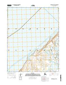
2014 Map of Wainwright B-3 NW
USGS Topo · Published 2014About this map
The Chukchi Sea dominates the landscape in this Arctic coastal survey, where the saltwater environment meets the barrier islands and inlet waters of Kasegaluk Lagoon. Situated within the Alaska North Slope Borough, this section of the coast is characterized by complex hydrography and shifting shorelines. The map details the delicate boundary between open ocean and the protected lagoon system, a critical area for regional subsistence and seasonal travel. While the terrain is sparse of permanent structures, the survey provides precise elevation data and Public Land Survey System grids, including t13n r34w and t12n r35w, which are essential for navigating and documenting this remote portion of the Alaskan shoreline.
Find a feature on this map
7 named features on this map. Tap any name to fly to it.
Don’t see what you’re looking for? This feature index may not catch every label — zoom into the map to look around manually.
Map Details
Editions of this 2014 Wainwright B-3 NW Map
This is the sole edition of this map. No revisions or reprints were ever made.
Other maps of this area

1951 · Wainwright
USGS Topo · 1:250,000

1955 · Wainwright
USGS Topo · 1:250,000
1955 · Wainwright B-3
USGS Topo · 1:63,360
1955 · Wainwright B-4
USGS Topo · 1:63,360
1955 · Wainwright C-3
USGS Topo · 1:63,360

1964 · Wainwright
USGS Topo · 1:250,000
2014 · Wainwright B-4 SE
USGS Topo · 1:25,000
2014 · Wainwright B-3 SW
USGS Topo · 1:25,000
2014 · Wainwright C-3 SE
USGS Topo · 1:25,000
2014 · Wainwright B-3 SE
USGS Topo · 1:25,000