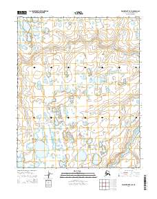
2014 Map of Wainwright B-3 SE
USGS Topo · Published 2014About this map
Apikuguruak Cr meanders through the Arctic coastal plain in this northern reach of the North Slope. The landscape is a complex mosaic of thaw lakes and drainage channels typical of the continuous permafrost zone, where water defines every boundary. In the southeastern corner, the Ivisaruk River cuts through the tundra, part of a vast watershed that has sustained traditional subsistence for generations. The map is organized by the Public Land Survey System grids, including t11n r34w and t12n r33w, illustrating how modern administrative boundaries are superimposed over a landscape shaped by glacial and fluvial processes.
Find a feature on this map
8 named features on this map. Tap any name to fly to it.
Don’t see what you’re looking for? This feature index may not catch every label — zoom into the map to look around manually.
Map Details
Editions of this 2014 Wainwright B-3 SE Map
This is the sole edition of this map. No revisions or reprints were ever made.
Other maps of this area

1951 · Wainwright
USGS Topo · 1:250,000

1955 · Wainwright
USGS Topo · 1:250,000

1955 · Wainwright A-2
USGS Topo · 1:63,360
1955 · Wainwright A-3
USGS Topo · 1:63,360
1955 · Wainwright B-2
USGS Topo · 1:63,360
1955 · Wainwright B-3
USGS Topo · 1:63,360

1964 · Wainwright
USGS Topo · 1:250,000
2014 · Wainwright A-3 NW
USGS Topo · 1:25,000
2014 · Wainwright B-2 SW
USGS Topo · 1:25,000
2014 · Wainwright B-3 NW
USGS Topo · 1:25,000