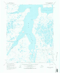
1955 Map of Wainwright B-2
USGS Topo · Published 1971About this map
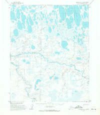
The massive waterway of the Kuk River dominates this mid-century Arctic landscape, serving as the central drainage for a complex network of coastal rivers and tundra wetlands. Mapping conducted in 1955 reveals a remote territory where transportation was dictated by the seasons and the water, noted by a Tractor Trail cutting through the eastern terrain near the Omalik River. This era of exploration in the Naval Petroleum Reserve No. 4 is marked by isolated industrial markers, including a Mine located north of Kilich Point. The geography is defined by low-lying points and islands, such as Kikkaugruak Island and Neakok Island, which sit at the confluence of the Ivisaruk River and the main channel. This survey documents the intricate shoreline and drainage patterns of the Alataktok River and Kungok River before modern infrastructure reached this portion of the North Slope.
Find a feature on this map
16 named features on this map. Tap any name to fly to it.
Don’t see what you’re looking for? This feature index may not catch every label — zoom into the map to look around manually.
Map Details
Editions of this 1955 Wainwright B-2 Map
This is the sole edition of this map. No revisions or reprints were ever made.
Other maps of this area

1951 · Wainwright
USGS Topo · 1:250,000

1955 · Wainwright
USGS Topo · 1:250,000

1955 · Wainwright A-2
USGS Topo · 1:63,360

1955 · Wainwright B-1
USGS Topo · 1:63,360
1955 · Wainwright A-3
USGS Topo · 1:63,360

1955 · Wainwright C-1
USGS Topo · 1:63,360
1955 · Wainwright C-2
USGS Topo · 1:63,360
1955 · Wainwright B-3
USGS Topo · 1:63,360
1955 · Wainwright A-1
USGS Topo · 1:63,360
1955 · Wainwright C-3
USGS Topo · 1:63,360