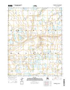
2014 Map of Wainwright C-1 NW
USGS Topo · Published 2014About this map
The Arctic coastal plain of the North Slope is defined by a complex network of thaw lakes and meandering watercourses. The most prominent hydrological feature on this sheet is Avgumun Cr, which snakes through the eastern half of the terrain. The landscape is marked by the distinctive Public Land Survey System grid, including the boundaries of t16n r30w, t16n r29w, t15n r30w, and t15n r29w. This particular area is a high-latitude wetland environment where the drainage patterns of small creeks and countless unnamed ponds demonstrate the unique permafrost-driven topography typical of northern Alaska.
Find a feature on this map
5 named features on this map. Tap any name to fly to it.
Don’t see what you’re looking for? This feature index may not catch every label — zoom into the map to look around manually.
Map Details
Editions of this 2014 Wainwright C-1 NW Map
This is the sole edition of this map. No revisions or reprints were ever made.
Other maps of this area

1951 · Wainwright
USGS Topo · 1:250,000

1955 · Wainwright
USGS Topo · 1:250,000

1955 · Wainwright C-1
USGS Topo · 1:63,360
1955 · Wainwright D-2
USGS Topo · 1:63,360
1955 · Wainwright C-2
USGS Topo · 1:63,360
1955 · Wainwright D-1
USGS Topo · 1:63,360
1962 · Wainwright D-2
USGS Topo · 1:50,000

1964 · Wainwright
USGS Topo · 1:250,000
2014 · Wainwright D-1 SW
USGS Topo · 1:25,000
2014 · Wainwright C-1 SE
USGS Topo · 1:25,000