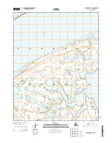
2014 Map of Wainwright D-1 SW
USGS Topo · Published 2014About this map
Chukchi Sea and Arctic Ocean waters dominate the northern reaches of this coastal landscape on the North Slope. The terrain is characterized by a complex network of coastal lagoons, small ponds, and braided waterways that shift across the low-lying tundra. The Igklo River winds northward through the center of the sheet, eventually emptying into the sheltered waters of Kugrua Bay to the east. This 2014 survey documents the intricate interface between the land and the sea in a region defined by its hydrology rather than permanent settlements or infrastructure. The lack of roads or established towns underscores the isolation of this Arctic environment, where the shifting courses of rivers like the Igklo and the seasonal presence of ice in the Chukchi Sea dictate the character of the land.
Find a feature on this map
10 named features on this map. Tap any name to fly to it.
Don’t see what you’re looking for? This feature index may not catch every label — zoom into the map to look around manually.
Map Details
Editions of this 2014 Wainwright D-1 SW Map
This is the sole edition of this map. No revisions or reprints were ever made.
Other maps of this area

1951 · Wainwright
USGS Topo · 1:250,000

1955 · Wainwright
USGS Topo · 1:250,000

1955 · Wainwright C-1
USGS Topo · 1:63,360
1955 · Wainwright D-2
USGS Topo · 1:63,360
1955 · Wainwright C-2
USGS Topo · 1:63,360
1955 · Wainwright D-1
USGS Topo · 1:63,360
1962 · Wainwright D-2
USGS Topo · 1:50,000

1964 · Wainwright
USGS Topo · 1:250,000
2014 · Wainwright C-1 NW
USGS Topo · 1:25,000
2014 · Wainwright C-2 NE
USGS Topo · 1:25,000