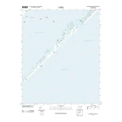
2010 Map of Wainwright Island
USGS Topo · Published 2010About this map
North Core Banks and a network of coastal islands define this maritime landscape along the Atlantic Ocean. The survey captures the complex estuarine environment of the Outer Banks, where shifting sands and shoals create a dynamic interface between land and sea. Landmarks such as Wainwright Island and the Pilontary Islands emerge from the sound, while named coastal features like Old House Beach and The Sands point to long-standing local naming traditions for specific stretches of the barrier beach. Inland transition zones are marked by Merkle Hammock and George Hills, providing subtle elevation in an otherwise low-lying coastal plain. While largely undeveloped, the presence of the Oyster Creek Pit near Cowpen Point indicates localized resource extraction within the marshy fringes of the coastline.
Find a feature on this map
19 named features on this map. Tap any name to fly to it.
Don’t see what you’re looking for? This feature index may not catch every label — zoom into the map to look around manually.
Map Details
Editions of this 2010 Wainwright Island Map
This is the sole edition of this map. No revisions or reprints were ever made.
Other maps of this area

1948 · Portsmouth
USGS Topo · 1:24,000

1948 · North Bay
USGS Topo · 1:24,000

1949 · Atlantic
USGS Topo · 1:24,000

1949 · Styron Bay
USGS Topo · 1:24,000

1950 · Portsmouth
USGS Topo · 1:24,000

1950 · North Bay
USGS Topo · 1:24,000
1951 · Atlantic
USGS Topo · 1:24,000
1951 · Styron Bay
USGS Topo · 1:24,000

1953 · Rocky Mount
USGS Topo · 1:250,000

1953 · Beaufort
USGS Topo · 1:250,000