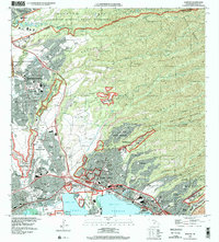
1998 Map of Waipahu
USGS Topo · Published 2000About this map
Pearl Harbor and its branching lochs define the southern edge of this late-1990s landscape, where the urban expansion of Pearl City and Waipahu meets the rugged terrain of the Koolau Range. The map illustrates a densely populated corridor following the h1 and h2 freeways, connecting military hubs like Wheeler Air Force Base and the Schofield Barracks Military Reservation with residential centers such as Mililani Town.
Find a feature on this map
58 named features on this map. Tap any name to fly to it.
Don’t see what you’re looking for? This feature index may not catch every label — zoom into the map to look around manually.
Map Details
Editions of this 1998 Waipahu Map
This is the sole edition of this map. No revisions or reprints were ever made.
Other maps of this area

1953 · Haleiwa
USGS Topo · 1:24,000

1953 · Schofield Barracks
USGS Topo · 1:24,000

1953 · Honolulu
USGS Topo · 1:24,000

1953 · Ewa
USGS Topo · 1:24,000

1953 · Puuloa
USGS Topo · 1:24,000

1953 · Hauula
USGS Topo · 1:24,000

1954 · Oahu
USGS Topo · 1:250,000

1954 · Kahana
USGS Topo · 1:24,000

1954 · Kaneohe
USGS Topo · 1:24,000

1954 · Waipahu
USGS Topo · 1:24,000