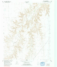
1962 Map of Waka SW
USGS Topo · Published 1992About this map
Palo Duro Creek and its tributaries carve a deep, intricate drainage system through the Texas Panhandle in this 1962 topographical study. The landscape is defined by the extensive energy infrastructure of the High Plains, dominated by the Hansford North Gas and Oil Field, the Spearman North Gas and Oil Field, and the Hansford Gas and Oil Field. This survey captures the region during a peak era of petroleum production, showing the dense network of pipelines and wells that overlay the natural erosion patterns of the caprock. Near the southern edge of the sheet, the terrain transitions into the watershed of Horse Creek, where a local Quarry and scattered ranch improvements suggest the mixed industrial and agricultural utility of this Hansford County landscape.
Find a feature on this map
6 named features on this map. Tap any name to fly to it.
Don’t see what you’re looking for? This feature index may not catch every label — zoom into the map to look around manually.
Map Details
Editions of this 1962 Waka SW Map
2 editions found
Other maps of this area

1954 · Perryton
USGS Topo · 1:250,000

1958 · Perryton
USGS Topo · 1:250,000

1962 · Kimball
USGS Topo · 1:24,000

1962 · Hansford Camp
USGS Topo · 1:24,000

1962 · Hansford
USGS Topo · 1:24,000

1962 · Waka SW
USGS Topo · 1:24,000

1962 · Spearman
USGS Topo · 1:24,000

1973 · Horseshoe Hill
USGS Topo · 1:24,000

1973 · Waka
USGS Topo · 1:24,000

1973 · Spearman NE
USGS Topo · 1:24,000