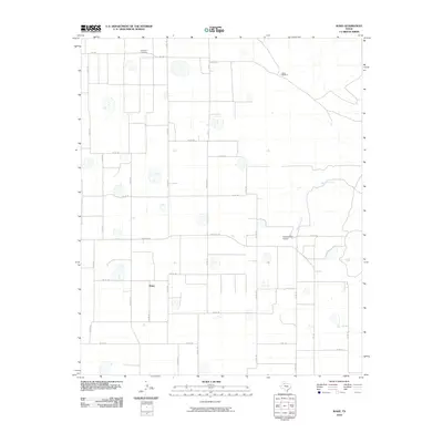
2010 Map of Wake
USGS Topo · Published 2010About this map
Antelope Cemetery stands as a quiet landmark in the northern reaches of this Crosby County landscape, north of the small community of Wake. The terrain is defined by a dense grid of farm-to-market and county roads, reflecting a highly organized agricultural layout typical of the Texas South Plains. Intermittent water features and small depressions dot the map, while Rustler Creek provides a natural drainage pattern across the eastern sections. Modern agricultural aviation is evident at the Gardner Farm Airport located along Ranch RD 193. Utility and infrastructure labels like Plains Windmill suggest the reliance on groundwater in this high plains environment. The network of roads, including FM 28 and Ranch RD 28, connects isolated homesteads and farmstead plots, illustrating the distribution of the rural population during the early 21st century.
Find a feature on this map
36 named features on this map. Tap any name to fly to it.
Don’t see what you’re looking for? This feature index may not catch every label — zoom into the map to look around manually.
Map Details
Editions of this 2010 Wake Map
This is the sole edition of this map. No revisions or reprints were ever made.
Other maps of this area

1954 · Lubbock
USGS Topo · 1:250,000

1965 · Wake
USGS Topo · 1:24,000

1965 · Boothe
USGS Topo · 1:24,000

1966 · Crosbyton
USGS Topo · 1:24,000

1966 · Mount Blanco
USGS Topo · 1:24,000

1966 · McAdoo
USGS Topo · 1:24,000

1967 · Haystack Mountain
USGS Topo · 1:24,000

1968 · Mac Bain
USGS Topo · 1:24,000

1968 · Rustler Camp
USGS Topo · 1:24,000
1968 · Dougherty
USGS Topo · 1:24,000