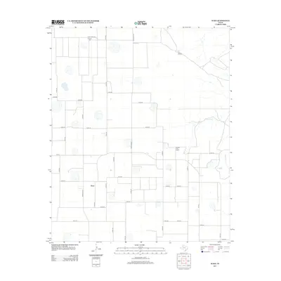
2012 Map of Wake
USGS Topo · Published 2012About this map
Wake serves as the central hub of this agricultural landscape in the Texas Panhandle, where a sprawling network of section roads and ranch-to-market routes organizes the high plains. The terrain is punctuated by numerous small playa basins and intermittent drainages like Rustler Cr and Grapevine Cr to the east. Local history is anchored by the Antelope Cem in the north and family-associated landmarks such as the Gardner Farm Airport and the Plains Windmill. Large-scale ranching and farming operations are evident through the naming of locales like Rustler Camp, reflecting the region's enduring cattle and cotton economy. This 2012 survey documents the persistent grid of county roads, including Ranch Road 1958 and Fm-193, which connect these dispersed homesteads and water sources across the Llano Estacado.
Find a feature on this map
37 named features on this map. Tap any name to fly to it.
Don’t see what you’re looking for? This feature index may not catch every label — zoom into the map to look around manually.
Map Details
Editions of this 2012 Wake Map
This is the sole edition of this map. No revisions or reprints were ever made.
Other maps of this area

1954 · Lubbock
USGS Topo · 1:250,000

1965 · Wake
USGS Topo · 1:24,000

1965 · Boothe
USGS Topo · 1:24,000

1966 · Crosbyton
USGS Topo · 1:24,000

1966 · Mount Blanco
USGS Topo · 1:24,000

1966 · McAdoo
USGS Topo · 1:24,000

1967 · Haystack Mountain
USGS Topo · 1:24,000

1968 · Mac Bain
USGS Topo · 1:24,000

1968 · Rustler Camp
USGS Topo · 1:24,000
1968 · Dougherty
USGS Topo · 1:24,000