
1955 Map of Wakefield
USGS Topo · Published 1957About this map
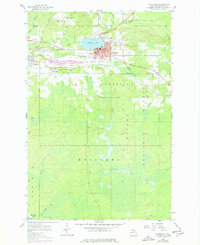
The iron mining legacy of the Gogebic Range is evident across this mid-century survey of Wakefield, where deep industrial scars and urban infrastructure define the landscape. Centered on Sunday Lake, the city is surrounded by massive Mine Dumps and active operations such as the Sunday Lake Mine and the Loomis Mine west of the city center. The Chicago and North Western railroad provides the primary industrial artery, winding through the valley to serve the local settlements of Ramsay, Plymouth, and Verona. South of the city limits, the terrain shifts abruptly into the densely wooded expanse of the Ottawa National Forest, where the Black River and Little Black River meander through marshy lowlands. This map captures the town's peak industrial footprint, from the High Sch and City Hall to the outlying Ramsay Lookout Tower and Lakeside Cem.
Find a feature on this map
35 named features on this map. Tap any name to fly to it.
Don’t see what you’re looking for? This feature index may not catch every label — zoom into the map to look around manually.
Map Details
Editions of this 1955 Wakefield Map
2 editions found
Other maps of this area

1943 · Ironwood
USGS Topo · 1:48,000

1953 · Ashland
USGS Topo · 1:250,000

1955 · Bessemer
USGS Topo · 1:24,000

1955 · Wakefield
USGS Topo · 1:62,500

1955 · Wakefield NE
USGS Topo · 1:24,000

1955 · Ironwood
USGS Topo · 1:62,500

1956 · North Ironwood
USGS Topo · 1:62,500

1956 · Thomaston
USGS Topo · 1:62,500

1958 · Ashland
USGS Topo · 1:250,000

1958 · Iron River
USGS Topo · 1:250,000