
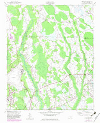
1949 Map of Wakulla
USGS Topo · Published 1953About this map
Lumber River meanders through a landscape of dense swamps and scattered agricultural settlements in this 1949 survey. The area is defined by the convergence of Gum Swamp, Long Swamp, and Jordan Swamp, which dictate the placement of local infrastructure and homes. Notable for researchers is the concentration of community landmarks, including Floral College and the Laurinburg-Maxton Airport, the latter situated near the County Memorial Hospital and a local Packing Plant. Transport across these wetlands relied on the Atlantic Coast Line railroad, which cuts diagonally through the terrain. The map is particularly dense with genealogical markers, such as McPhatter Cem, McLean Cem, and Wilkinson Cem, alongside numerous country schools like Burlington Sch and Cherokee Sch, illustrating the dispersed but organized rural life of mid-century Robeson County.
Find a feature on this map
45 named features on this map. Tap any name to fly to it.
Don’t see what you’re looking for? This feature index may not catch every label — zoom into the map to look around manually.
Map Details
Editions of this 1949 Wakulla Map
2 editions found
Other maps of this area

1949 · Wagram
USGS Topo · 1:24,000

1949 · Laurinburg
USGS Topo · 1:24,000

1949 · Silver Hill
USGS Topo · 1:24,000

1949 · Laurinburg
USGS Topo · 1:62,500

1953 · Florence
USGS Topo · 1:250,000

1954 · Florence
USGS Topo · 1:250,000

1957 · Laurinburg
USGS Topo · 1:24,000

1971 · Johns
USGS Topo · 1:24,000
1972 · Raeford
USGS Topo · 1:24,000

1972 · Pembroke
USGS Topo · 1:24,000