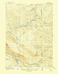
1914 Map of Walcott
USGS Topo · Published 1949About this map
The North Platte River carves a winding path through this high-altitude landscape of Carbon County, anchoring a terrain defined by early ranching operations and strategic rail connections. In the years following the 1912 survey, several family-named landmarks such as Ferris Ranch, Carson Ranch, and Miller Ranch illustrate the localized settlement pattern along the riverbanks and mountain foothills. The southern portion of the map is dominated by the industrial and transport corridor of the Union Pacific railroad, which links the settlements of Fort Steele, Walcott, and Edson. The map captures an intricate system of irrigation, featuring the North Ditch, Middle Ditch, and St Marys ditch, revealing the human effort to manage water across the arid stretches near Alkali Flat. Topographical features like Mt Steele and Cedar Ridge rise sharply above the river valley, providing a clear view of the complex geography that challenged early surveyors Frank Tweedy and Frank L. Whaley.
Find a feature on this map
25 named features on this map. Tap any name to fly to it.
Don’t see what you’re looking for? This feature index may not catch every label — zoom into the map to look around manually.
Map Details
Editions of this 1914 Walcott Map
2 editions found
Other maps of this area

1893 · Fort Steele
USGS Topo · 1:125,000

1914 · Hanna
USGS Topo · 1:62,500

1914 · Walcott
USGS Topo · 1:62,500

1953 · Wild Horse Mountain
USGS Topo · 1:24,000

1953 · Sinclair
USGS Topo · 1:24,000

1953 · Seminoe Dam SW
USGS Topo · 1:24,000

1953 · Seminoe Dam SE
USGS Topo · 1:24,000

1953 · Schneider Ridge
USGS Topo · 1:24,000

1953 · Lone Haystack Mountain
USGS Topo · 1:24,000

1954 · Rawlins
USGS Topo · 1:250,000