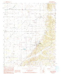
1983 Map of Walcott
USGS Topo · Published 1993About this map
Crowleys Ridge defines the eastern vertical of this landscape, rising sharply from the alluvial plains of Greene County. This geological formation provides a stark contrast to the flat agricultural lands to the west, where an extensive network of drainage features like Irr Ditch, Poplar Creek Ditch, and Gum Slough facilitate farming. The transition from the ridge to the bottoms is where the community of Walcott and the Crowleys Ridge State Park are situated, taking advantage of the varied elevation.
Find a feature on this map
20 named features on this map. Tap any name to fly to it.
Don’t see what you’re looking for? This feature index may not catch every label — zoom into the map to look around manually.
Map Details
Editions of this 1983 Walcott Map
2 editions found
Other maps of this area

1932 · Walnut Ridge
USGS Topo · 1:62,500

1935 · Sedgwick
USGS Topo · 1:62,500

1935 · Walnut Ridge
USGS Topo · 1:62,500

1939 · Jonesboro
USGS Topo · 1:62,500

1940 · Gainesville
USGS Topo · 1:62,500

1953 · Memphis
USGS Topo · 1:250,000

1956 · Memphis
USGS Topo · 1:250,000

1957 · Poplar Bluff
USGS Topo · 1:250,000

1958 · Jonesboro
USGS Topo · 1:62,500

1958 · Gainesville
USGS Topo · 1:62,500