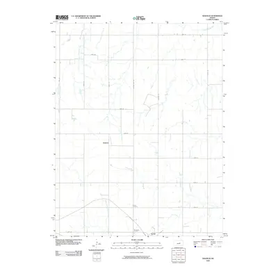
2009 Map of Waldeck
USGS Topo · Published 2009About this map
Lehigh anchors the southern edge of this Marion County landscape, situated at the intersection of E Main St and the surrounding grid of section roads. The area is defined by its agrarian structure and a network of waterways including the South Cottonwood River and North Cottonwood River, which meander through the central Kansas plains. A notable local history detail is found in the presence of the Mennonite Cemetery and Lehigh Cemetery, situated north of the main settlement near the headwaters of French Creek. These sites reflect the cultural heritage and early community foundations of the region. Further north, the small community of Waldeck sits along the banks of Perry Creek. The road network preserves historical routes, most notably Chisholm Trail Rd, which runs north-south through the center of the survey area, tracing the legacy of old cattle driving trails.
Find a feature on this map
25 named features on this map. Tap any name to fly to it.
Don’t see what you’re looking for? This feature index may not catch every label — zoom into the map to look around manually.
Map Details
Editions of this 2009 Waldeck Map
This is the sole edition of this map. No revisions or reprints were ever made.
Other maps of this area

1889 · Newton
USGS Topo · 1:125,000

1889 · Abilene
USGS Topo · 1:125,000

1894 · Newton
USGS Topo · 1:125,000

1894 · Abilene
USGS Topo · 1:125,000

1955 · Hutchinson
USGS Topo · 1:250,000

1959 · Hutchinson
USGS Topo · 1:250,000
1964 · Gypsum SE
USGS Topo · 1:24,000
1964 · Tampa
USGS Topo · 1:24,000
1964 · Roxbury
USGS Topo · 1:24,000

1971 · Durham
USGS Topo · 1:24,000