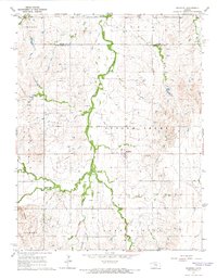
1964 Map of Roxbury
USGS Topo · Published 1966About this map
Roxbury serves as the central hub for this mid-1960s landscape, where the agricultural plains of central Kansas meet an active extraction economy. The map reveals a high density of petroleum infrastructure, with the Harvey Oil Field, Roxbury Oil Field, and Battle Hill Oil Field clearly delineated across the township sections. These fields are interspersed with local landmarks like Twin Mounds and the meandering course of Gypsum Creek. Local heritage is anchored by sites such as the Eureka Cem and Valley View Memorial Cem, providing valuable points of interest for genealogists tracing families in the Gypsum and Bonaville townships. The drainage patterns of Stag Creek and Battle Creek define the topography, illustrating the relationship between the natural water network and the developed South Roxbury Road.
Find a feature on this map
24 named features on this map. Tap any name to fly to it.
Don’t see what you’re looking for? This feature index may not catch every label — zoom into the map to look around manually.
Map Details
Editions of this 1964 Roxbury Map
3 editions found
Other maps of this area

1889 · Newton
USGS Topo · 1:125,000

1889 · Abilene
USGS Topo · 1:125,000

1891 · Hutchinson
USGS Topo · 1:125,000

1892 · Salina
USGS Topo · 1:125,000

1893 · Hutchinson
USGS Topo · 1:125,000

1894 · Newton
USGS Topo · 1:125,000

1894 · Abilene
USGS Topo · 1:125,000

1942 · Salina
USGS Topo · 1:125,000

1955 · Assaria
USGS Topo · 1:24,000

1955 · Gypsum
USGS Topo · 1:24,000