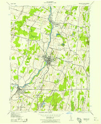
1942 Map of Walden
USGS Topo · Published 1958About this map
The Wallkill River defines the industrial and agricultural corridor of this Orange County region during the early 1940s. In Walden, the river's path is lined with infrastructure such as a Sewage Water Pump and Sewage Disposal Plant, while the village of Montgomery is marked by the Montgomery Worsted Mills and the Brescia Milk Co, highlighting a landscape balanced between manufacturing and the local dairy economy. The influence of the Borden family is particularly visible, with the Borden Estate, Borden Dairy Farm, and Borden High School concentrated near Wallkill.
Find a feature on this map
46 named features on this map. Tap any name to fly to it.
Don’t see what you’re looking for? This feature index may not catch every label — zoom into the map to look around manually.
Map Details
Editions of this 1942 Walden Map
This is the sole edition of this map. No revisions or reprints were ever made.
Other maps of this area

1902 · Schunemunk
USGS Topo · 1:62,500

1903 · Newburg
USGS Topo · 1:62,500

1904 · Ellenville
USGS Topo · 1:62,500

1906 · Ellenville
USGS Topo · 1:62,500

1906 · Goshen
USGS Topo · 1:62,500

1908 · Goshen
USGS Topo · 1:62,500

1930 · Schunemunk
USGS Topo · 1:48,000

1935 · Schunemunk
USGS Topo · 1:62,500

1938 · Goshen
USGS Topo · 1:62,500

1942 · Goshen
USGS Topo · 1:24,000