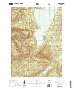
2020 Map of Waldo Lake
USGS Topo · Published 2020About this map
Waldo Lake dominates this high-altitude landscape within the Willamette National Forest, surrounded by a complex network of glacial basins and alpine meadows. The eastern shoreline is defined by recreational access points like Shadow Bay and Klovdahl Bay, while the western slopes of the Cascade Range drop sharply toward Black Creek and the notable Lillian Falls.
Find a feature on this map
84 named features on this map. Tap any name to fly to it.
Don’t see what you’re looking for? This feature index may not catch every label — zoom into the map to look around manually.
Map Details
Editions of this 2020 Waldo Lake Map
This is the sole edition of this map. No revisions or reprints were ever made.
Other maps of this area

1925 · Waldo Lake
USGS Topo · 1:125,000

1930 · Maiden Peak
USGS Topo · 1:125,000

1934 · Maiden Peak
USGS Topo · 1:125,000

1955 · Chucksney Mtn
USGS Topo · 1:62,500

1955 · Crescent
USGS Topo · 1:250,000

1956 · Waldo Lake
USGS Topo · 1:62,500

1957 · Crescent
USGS Topo · 1:250,000

1958 · Crescent
USGS Topo · 1:250,000

1958 · Roseburg
USGS Topo · 1:250,000

1959 · Roseburg
USGS Topo · 1:250,000