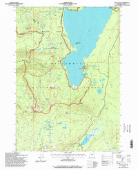
1997 Map of Waldo Lake
USGS Topo · Published 1998About this map
Waldo Lake dominates this high-country landscape in the late 1990s, its shoreline preserved within the Waldo Lake Wilderness and Willamette National Forest. The map details a complex network of glacial features and high-altitude water bodies, including Shadow Bay, Klovdahl Bay, and the solitary Rhododendron Island. This era of the forest is marked by a focus on conservation and backcountry recreation, evidenced by the presence of the Pacific Crest National Scenic Trail and remote outposts like the South Waldo Shelter and Fuji Shelter.
Find a feature on this map
54 named features on this map. Tap any name to fly to it.
Don’t see what you’re looking for? This feature index may not catch every label — zoom into the map to look around manually.
Map Details
Editions of this 1997 Waldo Lake Map
This is the sole edition of this map. No revisions or reprints were ever made.
Other maps of this area

1925 · Waldo Lake
USGS Topo · 1:125,000

1930 · Maiden Peak
USGS Topo · 1:125,000

1934 · Maiden Peak
USGS Topo · 1:125,000

1955 · Chucksney Mtn
USGS Topo · 1:62,500

1955 · Crescent
USGS Topo · 1:250,000

1956 · Waldo Lake
USGS Topo · 1:62,500

1957 · Crescent
USGS Topo · 1:250,000

1958 · Crescent
USGS Topo · 1:250,000

1958 · Roseburg
USGS Topo · 1:250,000

1959 · Roseburg
USGS Topo · 1:250,000