
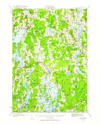
1913 Map of Waldoboro
USGS Topo · Published 1913About this map
The Medomak River corridor serves as the central artery for this coastal Maine region, where the economy and community life were firmly rooted in water and rail access before the First World War. Waldoboro emerges as a primary hub, supported by the Maine Central Railroad and several vital transit points including Waldoboro Station, Glendon Station, and Nobleboro Station. The landscape is densely packed with a network of local institutions, from the Old Dutch Church to numerous rural schoolhouses such as the Duck Puddle School, Goshen School, and the Niggertown School, reflecting a highly localized social structure common in the early 20th century.
Find a feature on this map
132 named features on this map. Tap any name to fly to it.
Don’t see what you’re looking for? This feature index may not catch every label — zoom into the map to look around manually.
Map Details
Editions of this 1913 Waldoboro Map
2 editions found
Other maps of this area

1893 · Vassalboro
USGS Topo · 1:62,500

1893 · Wiscasset
USGS Topo · 1:62,500

1893 · Boothbay
USGS Topo · 1:62,500

1898 · Vassalboro
USGS Topo · 1:62,500

1904 · Monhegan
USGS Topo · 1:62,500

1904 · Tenants Harbor
USGS Topo · 1:62,500

1904 · Rockland
USGS Topo · 1:62,500

1906 · Tennant Harbor
USGS Topo · 1:62,500

1906 · Monhegan
USGS Topo · 1:62,500

1906 · Rockland
USGS Topo · 1:62,500