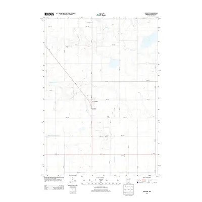
2013 Map of Waldorf
USGS Topo · Published 2013About this map
The town of Waldorf serves as the central hub of this Waseca County landscape, situated at the intersection of Main St and MN-83. The area is defined by a dense concentration of rural burial sites and places of worship, including Freedom Lutheran Church Cem and First Lutheran Church Cem, which reflect the early European settlement patterns of the region. The drainage of the land is managed through a system of natural waterways like the Little Cobb River and Bull Run Cr, alongside engineered features such as Judicial Ditch Number Fiftyone. These features reveal how the local agricultural economy relies on a carefully maintained watershed. Genealogists will find a high density of family-named cemeteries throughout the township, including Vivian Cem, Radloff Cem, Zoars Cem, and Hendrickson Cem, providing a detailed look at the community's historical footprint.
Find a feature on this map
39 named features on this map. Tap any name to fly to it.
Don’t see what you’re looking for? This feature index may not catch every label — zoom into the map to look around manually.
Map Details
Editions of this 2013 Waldorf Map
This is the sole edition of this map. No revisions or reprints were ever made.
Other maps of this area

1950 · Mankato East
USGS Topo · 1:62,500

1951 · Mankato East
USGS Topo · 1:62,500

1953 · Saint Paul
USGS Topo · 1:250,000

1954 · Mason City
USGS Topo · 1:250,000

1957 · Mason City
USGS Topo · 1:250,000

1958 · Mason City
USGS Topo · 1:250,000

1959 · Saint Paul
USGS Topo · 1:250,000

1966 · Waseca
USGS Topo · 1:24,000

1966 · Janesville
USGS Topo · 1:24,000

1967 · Minnesota Lake
USGS Topo · 1:24,000