
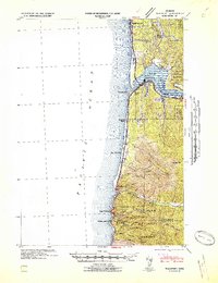
1942 Map of Waldport
USGS Topo · Published 1942About this map
Alsea Bay and the coastal mouth of the Alsea River serve as the focal point for this wartime coastal survey. The settlement of Waldport is positioned at the bay’s narrow opening, where the Oregon Coast Highway crosses the water. To the south, the landscape is defined by the steep rises of Cummins Ridge and Cape Ridge, with the Yachats River carving a valley toward the town of Yachats.
Find a feature on this map
44 named features on this map. Tap any name to fly to it.
Don’t see what you’re looking for? This feature index may not catch every label — zoom into the map to look around manually.
Map Details
Editions of this 1942 Waldport Map
2 editions found
Other maps of this area

1918 · Mapleton
USGS Topo · 1:48,000

1920 · Heceta Head
USGS Topo · 1:62,500

1922 · Waldport
USGS Topo · 1:62,500

1940 · Mapleton
USGS Topo · 1:62,500

1942 · Heceta Head
USGS Topo · 1:62,500

1942 · Yaquina
USGS Topo · 1:62,500

1942 · Tidewater
USGS Topo · 1:62,500

1942 · Toledo
USGS Topo · 1:62,500

1945 · Mapleton
USGS Topo · 1:62,500

1953 · Salem
USGS Topo · 1:250,000